Three optimized driving routes for an Alexa Mini hood-mount through the most ethnically diverse county on Earth — NW Queens to Far Rockaway QPL by 3:15 pm. Eight million people, 160+ languages, one SUV.
Steinway & Ditmars → Roosevelt Woodside to Jackson Heights → up 74th St (Nepali/Tibetan?) → Broadway in Elmhurst → Junction Blvd through Corona past Citi Field → Main St to Northern Blvd → QB through Rego Park/Forest Hills → Hillside Ave through Jamaica → Merrick Blvd through Black SE Queens → Far Rockaway
31st St beats Steinway — you get the elevated train. 74th area = yes Nepali/Tibetan. Don't miss the 5-way intersection in Elmhurst — "looks magnificently not like the US, a lot like India/Bangladesh." Flushing: try Roosevelt or 40th Rd or Prince St for "Honkers vibes." Woodhaven better than QB for Regostan. Lefferts/Richmond Hill — garlic-knots district, Trini/Indian. Airports part of the Queens story. And: the torii gates at the Queens/Nassau power-line border.
| # | Time | Location | Duration | What to Capture |
|---|---|---|---|---|
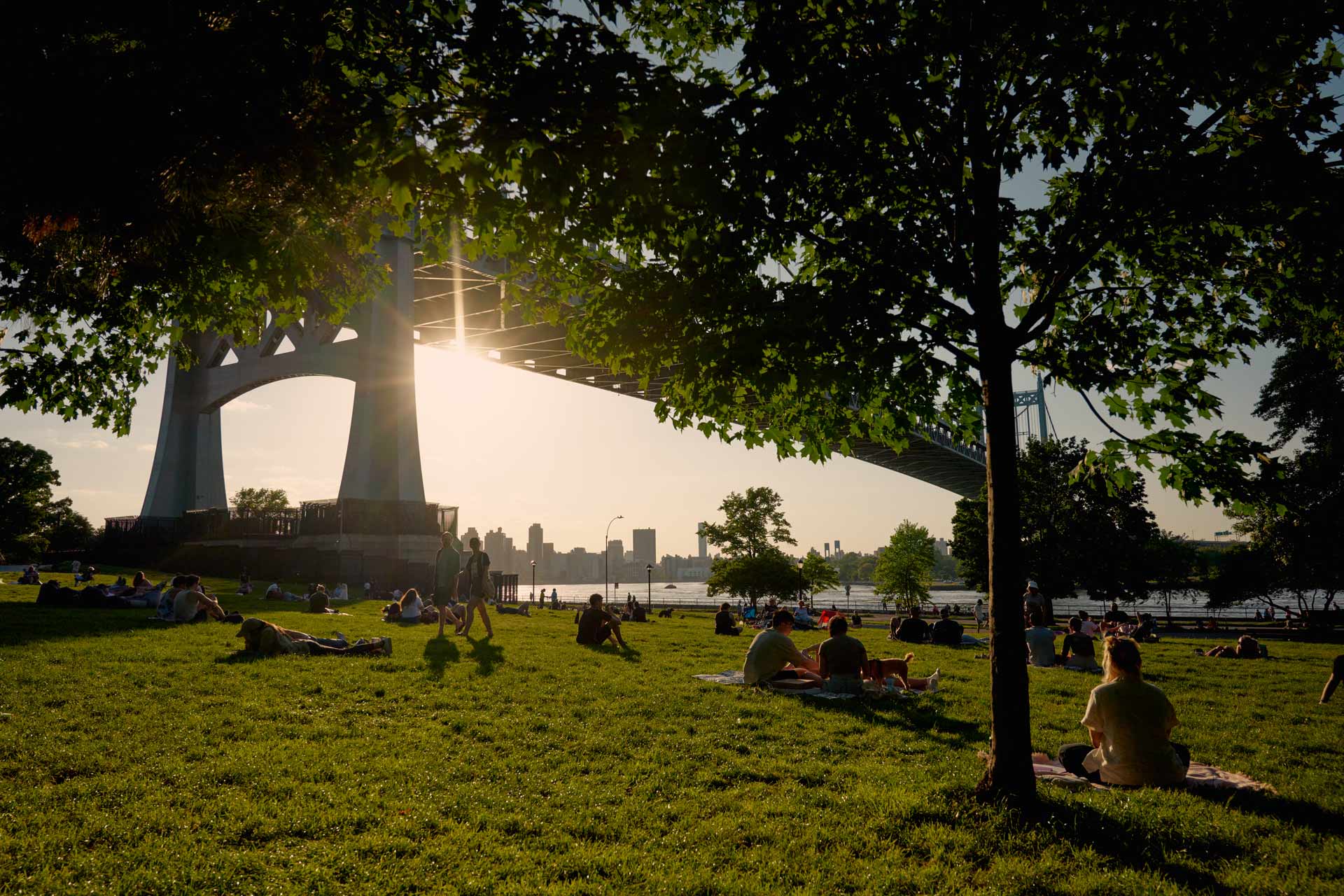
| 1 | 8:00 AM | 31st Ave & 31st St, AstoriaAstoria · N/W elevated train overhead | 15 min | Elevated N/W structure overhead. Multilingual commercial strip: Greek, Bangladeshi, Arabic, Korean, Latin American. Per Text 2: "31st St — if you take Steinway, you miss the train." Rolling hood-mount south under the elevated track; stop for pedestrian sequences at 31st Ave. |
| ↓ | 8:15 | Drive via Northern Blvd / Queens Blvd east → Jackson Heights (~30–35 min rush hour) | ||
| 2 | 8:50 AM | Roosevelt Ave & 74th St, Jackson HeightsJackson Heights · IRT Flushing Line overhead | 15 min | The defining shot of the route. 7 train elevated above Roosevelt; storefronts in Spanish, Bengali, Urdu, Nepali. The busiest subway station in Queens. Hood-mount rolling east under the elevated — faces compressed against iron pillars, sari shops, travel agencies, food carts. 9th busiest subway complex in all of NYC. |
| ↓ | 9:05 | Drive 3 blocks north to Diversity Plaza / 37th Ave (~5 min) | ||
| 3 | 9:10 AM | Diversity Plaza & 74th St areaJackson Heights · South Asian / Nepali / Tibetan | 15 min | Diversity Plaza: Bangladeshi, Indian, Colombian, Tibetan, Nepali businesses surrounding a literal public plaza. The 74th St corridor north of Roosevelt is where Nepali and Tibetan communities concentrate — per Text 2 confirmation. Small restaurant signs in Tibetan script. Phayul Tibetan café at 37-65 74th. Shoot the pedestrian density here; it's slower-paced than Roosevelt but richer for lingering faces. |
| ↓ | 9:25 | Drive via Broadway to Elmhurst (~12 min) | ||
| 4 | 9:37 AM | Broadway & Baxter Ave/Junction nexus, ElmhurstElmhurst · The "not-US" intersection | 12 min | The multi-way intersection near Broadway, Baxter Ave, and the 90th St area of Elmhurst that Text 2 calls "magnificently not like the US — a lot like India/Bangladesh." Newer Korean and Chinese businesses mix with South Asian medical offices and Latin American groceries. Broadway here is also the Asian commercial belt transitioning from Jackson Heights' South Asian density toward Flushing's East Asian core. Rolling shot through the intersection captures the density of diagonal street life. |
| ↓ | 9:49 | Drive Junction Blvd south to Roosevelt Ave, then east past Citi Field (~18 min) | ||
| 5 | 10:07 AM | Junction Blvd & Roosevelt Ave / Citi Field fly-byCorona · Ecuadorian / Mexican / Yucatec Maya | 15 min | Junction Blvd is the commercial spine of Corona's Latin American community — Ecuadorian restaurants, Yucatec Maya street vendors, Mexican panaderías. Anthony Bourdain filmed Evelia Coyotzi, a tamales vendor who speaks no English, right here. Then a rolling shot east on Roosevelt: Citi Field appears to the left, mural-covered walls, Corona Plaza with movable tables. The stadium as Queens landmark, surrounded by immigrant neighborhood — a defining contrast. |
| ↓ | 10:22 | Drive Roosevelt Ave east to Main St, Flushing (~28 min — traffic moderating) | ||
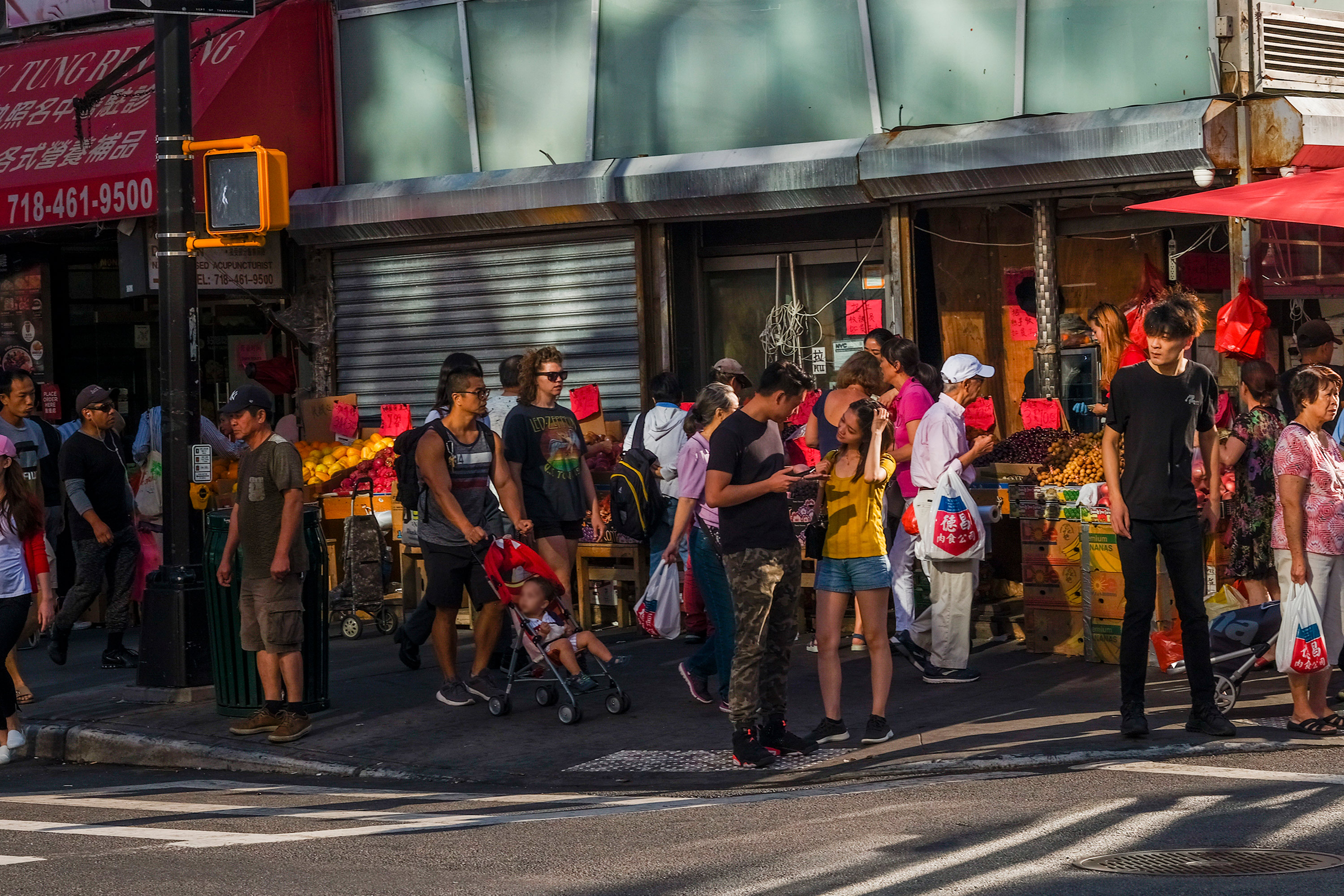
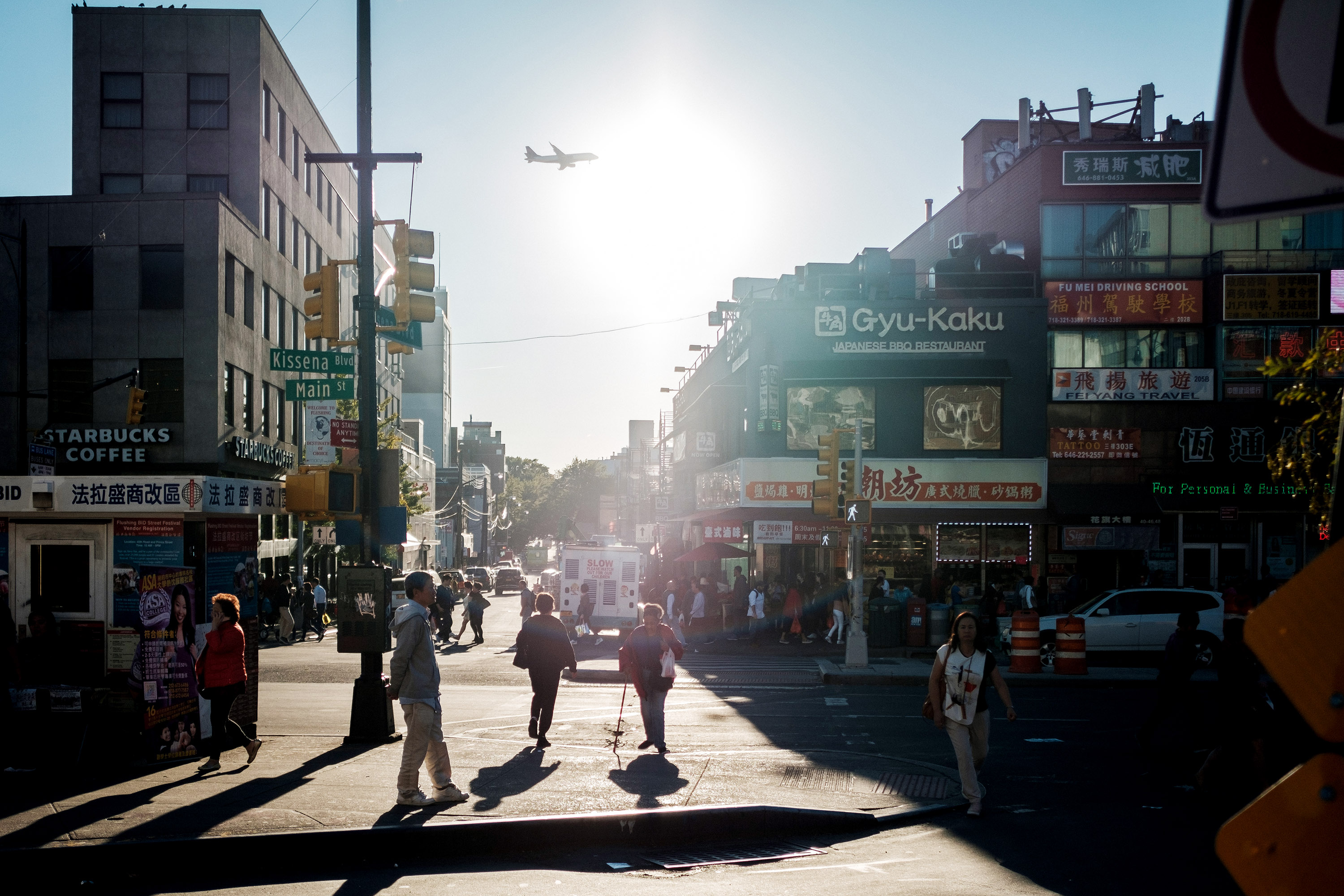
| 6 | 10:50 AM | Main St & Roosevelt Ave, FlushingFlushing · Chinese / Korean commercial core | 15 min | NYC's largest Chinatown by many accounts. Main St from Roosevelt north toward Northern Blvd: herbal medicine shops, Asian bakeries, bubble tea, Korean BBQ, dim sum, a dozen Chinese dialects plus Korean and Cantonese audible simultaneously. Extremely dense pedestrian traffic even on weekday mornings. The multilingual signage density here is the highest of any stop on this route — Simplified Chinese, Traditional Chinese, Korean, English, and Spanish in rapid visual succession. |
| ↓ | 11:05 | Drive south via Kissena Blvd / Hillside Ave to Jamaica Hills (~35 min) | ||
| 7 | 11:40 AM | Hillside Ave, Jamaica Hills (157th–168th St)Jamaica Hills · Bangladeshi / Caribbean / South Asian | 15 min | Per the Midnight Cowboy Scout: 9/10 — the top-ranked street in the entire borough for walking-sequence cinematography. Rolling east on Hillside: 83% of corridor users arrive by bus, so sidewalks are genuinely full. Bangladeshi pharmacies, halal restaurants, Caribbean bakeries, Tibetan tea shops. QPL Jamaica branch is 5 blocks south. At 11:40 AM the sun is high but the building density on both sides creates shade on north sidewalk — acceptable light for a moving vehicle. |
| ↓ | 11:55 | Drive north to Jamaica Ave / Jamaica Center (~15 min) | ||
| 8 | 12:10 PM | Jamaica Ave & Sutphin Blvd, Jamaica CenterJamaica · J/Z/E elevated · Caribbean / West Indian | 15 min | J and Z trains run elevated on Jamaica Ave — a completely different elevated train aesthetic from the 7 train: older ironwork, neighborhood commerce densely packed below. West Indian, Trinidadian, Guyanese, Nigerian, Sri Lankan, and Bangladeshi communities all visible within a two-block radius. Jamaica is QPL's core service territory. The convergence of A/C, E, J/Z, and LIRR makes this one of the busiest transit nodes in Queens. |
| ↓ | 12:25 | Drive south on Merrick Blvd (~10 min) | ||
| 9 | 12:35 PM | Merrick Blvd, South Jamaica / St. AlbansSouth Jamaica · Black American / Caribbean corridor | 15 min | Merrick Blvd through South Jamaica and St. Albans is one of Queens' historically Black commercial corridors — Caribbean-American grocery stores, West African hair salons, Black-owned restaurants and churches. The transition south from Jamaica Center into the residential SE Queens of St. Albans captures a completely different register of Queens life: quieter, more established, more residential. Rolling shot captures the storefronts before the street opens up toward the peninsula. |
| ↓ | 12:50 | Drive via Rockaway Blvd / Sunrise Hwy / Beach Channel Drive to Far Rockaway (~40 min) | ||
| ★ | 1:30 PM | Far Rockaway QPL BranchFar Rockaway · Arrive ~1:45 hrs early | — | Arrives approximately 1h45min before the 3:15 PM deadline. Buffer absorbs rush-hour overages, extends time at any stop, or enables a spontaneous additional stop on the way (e.g. Linden Blvd near JFK, or Rockaway Blvd at Resorts World). |
The complete immigrant arc of Queens — from the Mediterranean/Arab commercial strip of Astoria, through the South Asian/Latin corridor of Jackson Heights, the Chinese/Korean density of Flushing, and the Caribbean/West Indian neighborhoods of Jamaica. This is the foundational coverage of the documentary's subject matter. The 7 train elevated appears twice (Astoria's N/W and Jackson Heights' 7), giving you two distinct elevated train aesthetics at different speeds.
Rego Park / Forest Hills "Regostan" (Russian-Bukharian Jewish community on Woodhaven/108th St). Richmond Hill / Lefferts Blvd Indo-Trinidadian corridor (and Don Peppe's garlic knots — Italian holdout). The Queens/Nassau power-line border (torii gates vs. metal towers). The airport/casino transition zone on Rockaway Blvd. These require Route B or a second day. You also don't get the morning backlit window on Northern Blvd/Murray Hill (Route C's advantage).
Stop 1 — 31st Ave/Astoria: 114th Precinct. Greek/Arab/Bangladeshi corridor. No special sensitivities for a rolling vehicle; if exiting, Arabic-speaking producer or PA is an asset.
Stop 2-3 — 74th St/Jackson Heights & Diversity Plaza: 115th Precinct. The densest immigrant corridor on the route — Bengali, Nepali, Tibetan, Colombian. Bengali-speaking producer or PA is essential if anyone exits the vehicle for featured subject interaction. This is QPL Jamaica's direct service community. Release forms should be on set: Tier 1 Bengali, Spanish, English. Tier 2 Nepali, Hindi/Urdu.
Stop 5 — Junction Blvd/Corona: 110th Precinct. Ecuadorian/Mexican/Yucatec Maya corridor. Spanish-speaking producer required for any subject interaction.
Stop 7 — Hillside Ave, Jamaica Hills: 103rd Precinct. Sanctuary territory. A long lens from a slow-rolling vehicle reads less invasively than a planted tripod on the sidewalk — but if crew exits to work alongside the vehicle, the sanctuary-territory posture from Annoying Stuff § 3 applies. Bengali-speaking PA essential.
Release posture for all stops: A driving hood-mount capturing public street life creates no featured-subject liability as long as no individual face holds the frame for an extended edit. If an individual will be recognizable in the final cut, treat them as a featured subject and obtain a release. See Appendix B — Release Translation Matrix.
| # | Time | Location | Duration | What to Capture |
|---|---|---|---|---|
| 1 | 8:00 AM | Steinway St & Astoria Blvd (Little Egypt)Astoria · Arab / Egyptian / Yemeni / Greek | 15 min | Steinway between Astoria Blvd and 28th Ave: hookah lounges, Egyptian seafood restaurants, Yemeni coffee shops, Arabic-script storefronts. The mosque call to prayer, baklava vendors, halal grocery stores. Unlike 31st St, no elevated train here — but the cultural specificity is extraordinary and distinct. AbuQir Seafood went viral; Sabry's is 50+ years old. Rolling shot heading south through the corridor; stop at the 25th Ave crossroads for pedestrian density. |
| ↓ | 8:15 | Drive via Northern Blvd → Jackson Heights (~30 min rush hour) | ||
| 2 | 8:45 AM | 74th St & Broadway, Jackson HeightsJackson Heights · South Asian / Nepali / Tibetan epicenter | 15 min | The geographic center of Queens' South Asian immigrant life. The 74th St / Broadway intersection has sari and fabric shops, Bangladeshi restaurants, travel agencies to Dhaka and Delhi, Tibetan thangka paintings in shop windows. Rolling hood-mount through the 74th St corridor captures the most visually layered signage concentration in the route. Note: the 74th St subway complex is the 9th busiest in NYC. |
| ↓ | 9:00 | Drive via Queens Blvd south to Rego Park / Forest Hills (~25 min) | ||
| 3 | 9:25 AM | 108th St / Queens Blvd, Rego Park ("Regostan")Rego Park · Russian / Bukharian Jewish / Central Asian | 15 min | "Regostan" — the Bukharian Jewish community, largest outside Israel and Uzbekistan, concentrated on and near 108th St and 63rd Drive in Rego Park. Cyrillic-script grocery stores, Central Asian pilaf restaurants, men in embroidered yarmulkes, Russian-language kosher delis. Per Text 2: "Woodhaven better than QB for Regostan, but both might have glimpses." Rolling shot up 108th St captures the Central Asian-inflected commercial corridor that most Queens coverage overlooks entirely. |
| ↓ | 9:40 | Drive south on Woodhaven Blvd to Richmond Hill / Jamaica (~20 min) | ||
| 4 | 10:00 AM | Lefferts Blvd & Liberty Ave, Richmond HillRichmond Hill · Indo-Trinidadian / Guyanese / Italian holdout | 15 min | The "garlic knots district" — per Text 2: "From peak Trini/Indian to garlic knots" (Don Peppe's on Lefferts). Richmond Hill's Liberty Ave is dense with Trinidadian/Guyanese rotis shops, Guyanese curry houses, and Indo-Caribbean businesses, ending at Don Peppe, the old-school Italian-American restaurant that has held its corner for 50+ years. The collision between new immigrant commercial life and Italian-American holdout is cinematically charged. Lefferts Blvd north of Liberty captures the full Trini/Guyanese/Indian corridor. |
| ↓ | 10:15 | Drive north on Jamaica Ave / Sutphin to Jamaica Center (~15 min) | ||
| 5 | 10:30 AM | Jamaica Ave & Sutphin, Jamaica CenterJamaica · J/Z elevated · Caribbean / West Indian | 15 min | J/Z train elevated on Jamaica Ave — iron ironwork, neighborhood density below. Jamaica Center is one of Queens' largest outdoor commercial corridors: West Indian, Nigerian, Sri Lankan, Caribbean businesses. The A/E/J/Z transit hub makes it one of the busiest pedestrian areas in SE Queens. |
| ↓ | 10:45 | Drive east to Hillside Ave, Jamaica Hills (~20 min) | ||
| 6 | 11:05 AM | Hillside Ave, Jamaica Hills (157th–168th St)Jamaica Hills · Bangladeshi / South Asian spine | 15 min | Bangladeshi commercial corridor, 83% bus-using foot traffic, halal restaurants, sari shops, Caribbean bakeries. The QPL Jamaica branch is 5 blocks south. The Midnight Cowboy Scout ranks this as the best walking-sequence location in all of Queens (9/10). |
| ↓ | 11:20 | Drive east on Hillside Ave toward Nassau border (~25 min) | ||
| 7 | 11:45 AM | Union Tpke at Queens/Nassau border (near 245th St)Queens/Nassau border · Torii gates vs. metal towers | 12 min | The torii gates of Queens. Per Text 2: "The boundary between Queens and Nassau — demarcated by the wood vs. metal power lines." Old wooden utility poles on the Nassau side, metal on Queens — a subtle but real dividing line invisible to most people. A rolling shot heading east along Union Turnpike at ~245th Street captures the exact moment the borough ends: the power lines change, the sidewalks change, the density changes. A metaphor for the documentary: the border that defines what's inside. |
| ↓ | 11:57 | Drive south via Merrick Blvd / Rockaway Blvd to Far Rockaway (~50 min) | ||
| 8 | 12:47 PM | Merrick Blvd / Rockaway Blvd (rolling shot south)St. Albans → Springfield Gardens → Far Rockaway approach | rolling | Let the camera run as you drive south: Merrick Blvd through St. Albans and Springfield Gardens transitions from the Caribbean middle class into the residential grid of SE Queens. Rockaway Blvd passes directly by JFK Airport and Resorts World Casino at 110-00 Rockaway Blvd — a rolling shot past Resorts World captures what Text 2 called "the losers who look crestfallen and penniless upon exit." The peninsula approach via Beach Channel Drive ends at the Atlantic. |
| ★ | ~1:45 PM | Far Rockaway QPL BranchFar Rockaway · Arrive ~1:30 hrs early | — | Arrives with significant buffer. Misses Flushing and Corona (add those on a second day). If traffic on Woodhaven is heavy, the 108th St Rego Park stop can be shortened and the time recovered. |
The neighborhoods Route A can't reach in one day: Rego Park's Central Asian corridor, Richmond Hill's Indo-Trinidadian/Italian collision, and the Queens/Nassau border as a cinematic subject. Also captures Steinway's Little Egypt more deeply than a 31st Ave pass. The south-to-southeast geographic arc is fundamentally different from Route A's east-to-south spine — the two routes are genuinely complementary.
Flushing's Chinese/Korean commercial core is entirely absent — that's the single biggest gap. Corona and the Citi Field fly-by are also skipped. The 7 train elevated above Roosevelt Ave (the defining visual of the borough's immigrant story) is not in this route. These neighborhoods require either Route A or Route C for coverage.
Stop 1 — Steinway/Little Egypt (114th): The highest-sensitivity stop on either route. Arab and North African community has documented surveillance history. A slow-rolling vehicle is less threatening than a planted tripod — but do not stop, linger, or point a long lens at individuals exiting a mosque or at prayer. Arabic-speaking producer or PA essential if any exit.
Stop 3 — 108th St/Rego Park "Regostan" (112th): Bukharian Jewish and Russian community. Orthodox Jewish photography norms apply — do not film children, do not frame identifiable Orthodox subjects from a stopped vehicle without consent. Russian-speaking producer or PA assets. The rolling shot through the commercial corridor is low-risk; a stopped vehicle with a long lens pointed at the storefront is not.
Stop 4 — Lefferts Blvd/Richmond Hill (102nd): "Little Guyana Avenue" official designation gives QPL framing natural legitimacy here. Indo-Trinidadian and Sikh community. Hindi/Punjabi PA essential for any stop interaction. Roti shops and mandirs: do not film doorways during prayer times.
Stop 7 — Queens/Nassau border (107th): Lowest community-sensitivity on the route; primarily a landscape/infrastructure shot. No special protocols. Avoid stopping on the shoulder of Union Tpke in a way that reads as surveillance of residential Jamaica Estates.
| # | Time | Location | Duration | What to Capture |
|---|---|---|---|---|
| — | 8:00 | Drive from NW Queens directly to Murray Hill / Northern Blvd (no Astoria stop) (~40–45 min rush hour via LIE or Northern Blvd) | ||
| 1 | 8:45 AM | Northern Blvd, Murray Hill (~150th–160th St)Murray Hill / Flushing · Korean commercial corridor | 20 min | Peak morning backlit window: 8:00–9:00 AM. Per the Midnight Cowboy Scout: at 8 AM, the sun is at azimuth 86° — nearly perfectly aligned with Northern Blvd's east-west axis. Camera facing east (uphill toward Murray Hill) captures Korean-owned storefronts in rim-lit silhouette. Hangul-script signs catch the low morning sun. This is one of the densest Korean commercial corridors in NYC. A telephoto at 135mm from ~150th St compresses 10–12 blocks of Hangul neon and pedestrians into a single frame. The closest thing in Queens to the "beam down the corridor" shot. |
| ↓ | 9:05 | Drive 1 mile east to Main St, Flushing (~8 min) | ||
| 2 | 9:13 AM | Main St & Roosevelt Ave, Flushing coreFlushing · Chinese / Korean commercial density | 15 min | NYC's largest Chinatown: herbal medicine, dim sum, bubble tea, Korean BBQ, Chinese-language bookstores. Main St from Roosevelt north to Northern Blvd is a solid wall of multilingual commercial signage. Morning is one of the better times — the crowds are heavy but not yet peak-hour, and the street vendors are setting up. Hood-mount rolling north on Main captures the sidewalk-to-storefront layers. |
| ↓ | 9:28 | Drive 2 blocks west to Prince St / 40th Rd area (~5 min) | ||
| 3 | 9:33 AM | Prince St / 40th Rd, Downtown FlushingFlushing · "Honkers vibes" — narrow streets near the 7 train | 15 min | Per Text 2: "More exciting view of Flushing would be Roosevelt or 40th Rd. Or Prince Streets — those narrow ones near the train and up hills. Honkers vibes!" These streets just south and west of the main Flushing hub are narrower, more densely compressed, and visually closer to a Hong Kong side-street than anything else in New York. Signs hanging overhead between buildings, restaurants stacked two flights up, food stalls at street level. The 7 train's elevated structure creates overhead drama. A slow rolling shot at under 10mph captures what no walking shot can. |
| ↓ | 9:48 | Drive west to Jackson Heights / 74th St (~25 min) | ||
| 4 | 10:13 AM | Roosevelt Ave & 74th St / Diversity PlazaJackson Heights · South Asian / Nepali / Tibetan | 15 min | The Jackson Heights core — 7 train elevated, South Asian commercial density, Diversity Plaza. Light at 10 AM is less dramatic than Route A's 8:50 AM arrival, but still workable: the 7 train structure creates heavy shade on the south sidewalk while the north sidewalk has direct sun. Rolling east on Roosevelt then north on 74th captures the transition from Latin American storefronts under the elevated to South Asian/Nepali on the quieter blocks above 37th Ave. |
| ↓ | 10:28 | Drive south via Junction Blvd through Corona (~20 min) | ||
| 5 | 10:48 AM | Junction Blvd & Roosevelt Ave, Corona + Citi FieldCorona · Ecuadorian / Mexican / Latin American | 12 min | Junction Blvd's Latin American concentration, Citi Field rolling shot. Evelia Coyotzi's tamale cart neighborhood. Shorter stop than other routes — time was spent in Flushing. The Citi Field fly-by can be done as a rolling shot without stopping: drive past on Roosevelt Ave toward Van Wyck, capturing the stadium alongside Latin American murals and bodegas. |
| ↓ | 11:00 | Drive south to Jamaica via Hillside Ave (~30 min) | ||
| 6 | 11:30 AM | Hillside Ave, Jamaica Hills (157th–168th)Jamaica Hills · Bangladeshi / Caribbean | 15 min | The Bangladeshi-Caribbean commercial spine. Same stop as Route A — anchor of the Jamaica section. |
| ↓ | 11:45 | Drive to Jamaica Ave / Merrick Blvd south (~15 min) | ||
| 7 | 12:00 PM | Merrick Blvd through St. Albans / Springfield GdnsSE Queens · Caribbean-American / Black middle class | 15 min | Rolling south on Merrick captures the residential-commercial corridor of Black SE Queens — Caribbean groceries, Black-owned businesses, storefront churches — before the street opens toward the peninsula. Let the camera run all the way down to Rockaway Blvd and the JFK/Resorts World approach. The transition from dense immigrant Queens to the penultimate approach of the Atlantic Ocean is the documentary's natural closing arc. |
| ↓ | 12:15 | Drive via Rockaway Blvd / Beach Channel Drive to Far Rockaway (~45 min) | ||
| ★ | ~1:00 PM | Far Rockaway QPL BranchFar Rockaway · Arrive ~2:15 hrs early — most buffer of any route | — | Maximum buffer of the three routes. The extra time can be used to explore the Far Rockaway peninsula itself before the QPL appointment — the beach communities of Arverne, Rockaway Park, and Far Rockaway represent yet another cultural register of Queens entirely. |
The morning backlit window on Northern Blvd that neither Route A nor B exploits — the single best cinematographic opportunity of the day per the MC Scout. Deep Flushing coverage including the "Honkers vibes" streets that most Queens documentaries skip. More buffer time than either other route. The Flushing-first approach means the East Asian content arrives in optimal morning light rather than late-morning flat light.
No Astoria at all — the start goes directly east, bypassing Steinway and 31st Ave entirely. No Rego Park (Regostan). No Richmond Hill (Trinidadian). No Jamaica Ave elevated J train sequence. The south and west coverage is thin. Route C goes deep in one geographic area rather than wide across the borough.
Stop 1 — Northern Blvd, Murray Hill (109th): Korean commercial corridor. Korean cultural norms around image use are stricter than most other communities on the scout — Korean and Chinese seniors are the dominant pedestrian category. Korean-speaking producer or PA essential if any subject interaction. Murray Hill BID courtesy notification appreciated.
Stops 2-4 — Flushing (Prince St / 40th Rd / Main St) (109th): Densest crowd-management challenges on the route. Street vendors on Main St are photograph-averse. Mandarin-speaking producer essential; Cantonese-speaking PA strongly recommended. Flushing BID courtesy notification. At 25+ Chinese dialects spoken here, a bilingual Mandarin-Cantonese team handles the vast majority of subject interaction.
Stop 5 — Hillside Ave, Jamaica Hills (103rd): Sanctuary territory — same posture as Route A and Guide II. Bengali-speaking PA or producer on set. Optional Permit should name this stop explicitly given the precinct's community policing history.
Optional Permit timing: Generate the Letter in Lieu the day before for all planned stops. The 30-day validity means one filing covers this route and any reshoot days. List Northern Blvd, Main St/Flushing, and Hillside Ave by intersection in the certification form. See Annoying Stuff § 2 for the six-step filing process.
No single route covers Queens. The borough has 91 neighborhoods. Even the most optimistic interpretation of today's 7h15min window leaves significant material unfilmed. Here's an honest accounting of what each time budget buys.
One geographic arc, 8–9 stops, the foundational coverage. You get the Roosevelt spine or the Flushing deep cut or the southern circuit — not all three. Every route leaves multiple neighborhoods entirely unfilmed.
Best use: Route A captures the most story-per-mile. Start there. Everything else is additive.
Hard limitations: No morning backlit on Northern Blvd (need to be there by 8:45 AM — impossible with an Astoria start). No Rego Park. No Richmond Hill. No Flushing depth if you do Route A. No Astoria if you do Route C.
With 5 additional hours, you can film the 4–5 neighborhoods today's route misses — without time pressure. A 9 AM–2 PM window on any weekday gives you morning light and manageable traffic.
Priority additions: If you do Route A today, a second session covers Rego Park Regostan, Richmond Hill, deeper Flushing (Prince St / 40th Rd), the Queens/Nassau border, and Resorts World/JFK.
Two full days in Queens means covering all three routes' best stops, with time for light-quality passes: morning backlit on Northern Blvd and Hillside Ave, and golden-hour rolling shots on Roosevelt Ave heading west at 6:30 PM.
What becomes possible: Repeat passes on key stops in different light. Real spontaneity — getting out of the car when something unexpected happens. The 34th Ave Open Streets corridor any day at all.
One honest caveat: Queens has 91 neighborhoods, 160+ languages, 2.3 million residents, and 51% foreign-born. No single vehicle shoot — however well-planned — documents "Queens." These routes document the most cinematically accessible corridors of the most diverse county on Earth. The 90 neighborhoods not covered on these routes all have their own stories. That's the point of the film.
Hood-mount logistics: A slow-rolling shot (5–15 mph) captures more texture than a stop. Where possible, drive the stop-block twice: once to scout the best position, once for the actual take. Most of these streets have double-parking and turn restrictions — have Sydney flag potential stopping spots from the passenger seat before committing.
Rush hour reality: Thursday 8–9:30 AM in Queens is heavy. Northern Blvd and Queens Blvd are worst; Roosevelt Ave is better once you're east of LIC. Drive times in the tables above assume rush hour through 9:30 AM, then moderate traffic. Add 10–20 minutes of padding if you hit unexpected construction or signal work.
If you have to pick one stop: The Jackson Heights 74th St / Roosevelt Ave intersection. It's the densest convergence of the documentary's subject matter — South Asian, Latin American, Caribbean, Tibetan, Nepali communities — all under an elevated train on the world's most culturally diverse street. QPL has institutional access to this community. Everything else radiates outward from here.
Recommendation: Do Route A on May 7. Shoot Routes B and C's unique stops (Regostan, Richmond Hill, Northern Blvd, Prince St Flushing, Queens/Nassau border) on a separate half-day before the end of the shoot window. Both sessions together cover the borough's full cultural spectrum.